
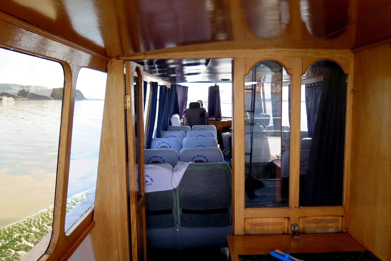
Day 5
Time to catch the soul train .

With a loud Colombian group .

Urubamba River
A partially navigable headwater of the Amazon River, it rises in the Andes to the southeast of Cuzco. It originates on the slopes of Khunurana in the Puno Region, Melgar Province, near the La Raya pass.[5] It flows north-north-west for 724 kilometers before coalescing with the Tambo River to form the Ucayali River.

Rapids all the way .

Sites of old Inca buildings .

Many along the way .

Finally we reach-

Machu Picchu !!

What is confusing is that there is 3 Machu Picchus in this area . 4 if you count the district .
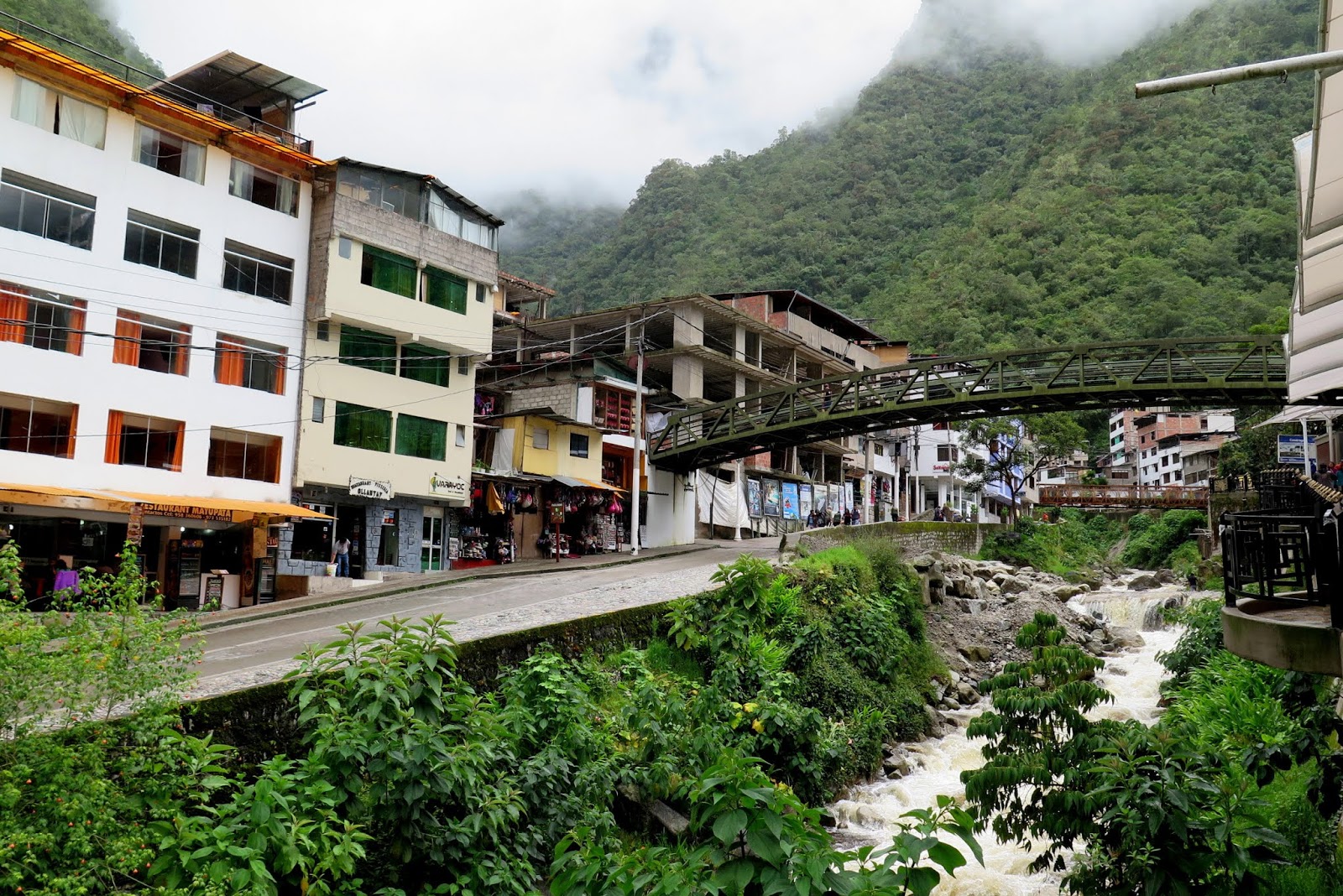
This is Machu Picchu town .

AKA Aguas Calientes

Machupicchu or Machupicchu Pueblo, also known as Aguas Calientes, is a location in Peru situated in the Cusco Region, Urubamba Province. It is the seat of the Machupicchu District. Machupicchu lies at the Vilcanota River. It is the closest access point to the historical site of Machu Picchu which is 6 kilometres (3.7 mi) away or about a 1.5 hours walk

The Urubamba River or Vilcamayo River (possibly from Quechua Willkamayu, for "sacred river") is a river in Peru. Upstream it is called Vilcanota River .

The town center .

Statue of Inka

We get on a bus and ride up the mountain.
Some (crazy) opt to walk .

The day is cloudy. Its a good thing we're spending 2 days here .

We reach the top.

This is the entrance to Machu Picchu citadel .

For those who like to walk .

Memorial to Hiram Bingham .

After all these years waiting...

We see fog :-(

Rain and fog up in the mountains .

Still awesome though.

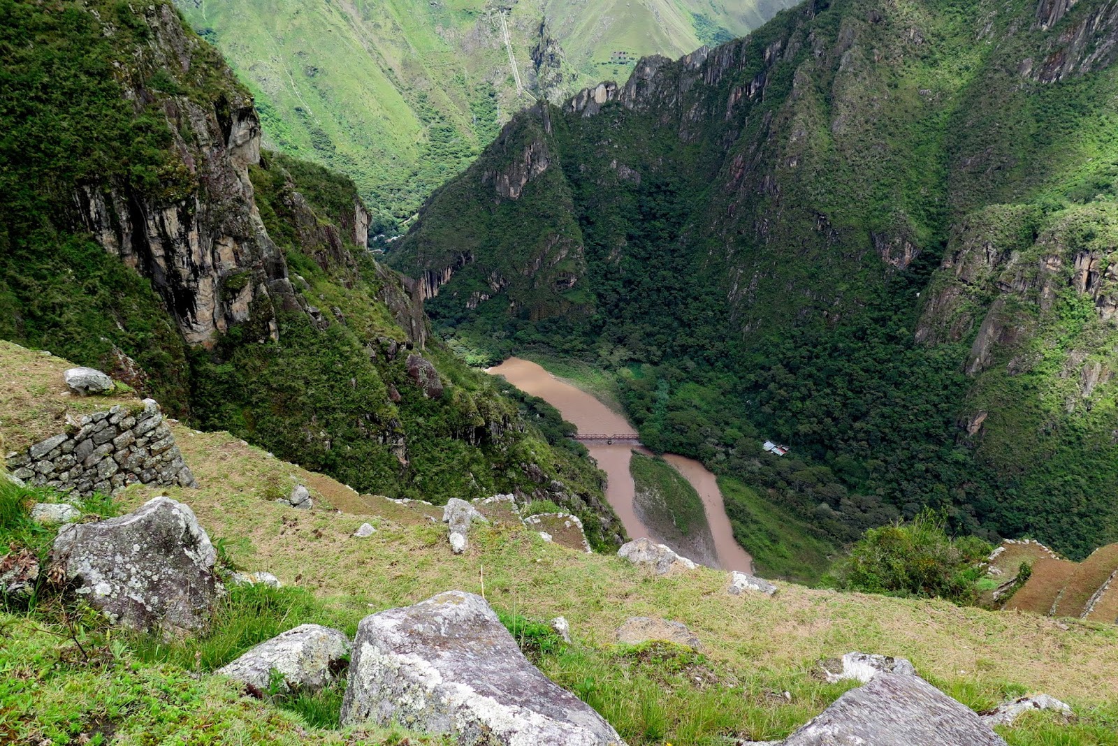
We can vaguely see the river at the base.

There .

Machu Picchu is a 15th-century Inca citadel, located in the Eastern Cordillera of southern Peru, on a mountain ridge 2,430 metres (7,970 ft) above sea level .

It is located in the Cusco Region, Urubamba Province, Machupicchu District in Peru, above the Sacred Valley, which is 80 kilometres (50 mi) northwest of Cuzco and through which the Urubamba River flows, which cuts through the Cordillera and originates a canyon with tropical mountain climate .

Most archaeologists believe that Machu Picchu was constructed as an estate for the Inca emperor Pachacuti (1438–1472). Often mistakenly referred to as the "Lost City of the Incas" (a title more accurately applied to Vilcabamba), it is the most familiar icon of Inca civilization.

The lone tree in the center .

We go up first .

To get this view .

Amazing .

In hindsight the fog gave us a nice view as the next day was bright and sunny .

The Incas built the estate around 1450 but abandoned it a century later at the time of the Spanish Conquest. Although known locally, it was not known to the Spanish during the colonial period and remained unknown to the outside world until American historian Hiram Bingham brought it to international attention in 1911

Machu Picchu was built in the classical Inca style, with polished dry-stone walls. Its three primary structures are the Intihuatana, the Temple of the Sun, and the Room of the Three Windows. Most of the outlying buildings have been reconstructed in order to give tourists a better idea of how they originally appeared

The residential section of the site .

For the royals and the commoners .

The royal area .

The terraces are for farming .

Memories .

Lots of terraces to support the populace .

Wet and cold .


Cold enough for gloves .

Soon we make our way down .

The central buildings use the classical Inca architectural style of polished dry-stone walls of regular shape. The Incas were masters of this technique, called ashlar, in which blocks of stone are cut to fit together tightly without mortar.

The section of the mountain where Machu Picchu was built provided various challenges that the Incas solved with local materials. One issue was the seismic activity due to two fault lines. It made mortar and similar building methods nearly useless. Instead, the Inca mined stones from the quarry at the site, lined them up and shaped them to fit together perfectly, stabilizing the structures


The Temple of the Sun is located in the urban sector and can be only entered through a large access gate, gate which was provided with double beams and a closure mechanism to provide the city with the necessary means of protection and security. According to anthropological researches, the exact location of the Citadel was chosen to place the city at the highest altitude and, thus, this location in turn get to contemplate heaven more closely. The Inca civilization believed that, a closer position to the Sun would allow a better and more appropriate location for the settlement, as well as for the practice of the different doctrines like astronomical studies.

Terraced fields in the upper agricultural sector

The building in the end are the industrial area .

The site is roughly divided into an urban sector and an agricultural sector, and into an upper town and a lower town. The temples are in the upper town, the warehouses in the lower.

Nice huh .

The Main Temple of the Machu Picchu

And the large plaza below .

Huayna Picchu in the distance .

We walk to the end .

Thatched roofs.

Located in the lower part of the Urban Sector ofMachu Picchu, the Sacred Rock (also ominously called a Wank'a in Quechua), is a large stone, surrounded by a small low wall. ... The Sacred Rock is a powerful symbol in Machu Picchu, and is recognized as being a spiritual area for meditation and absorbing positive energies.

The drainage still works .

We walk through the houses .

Nice huh .

See the hut . Behind that is Machu Picchu mountain . So that's the 3 Machu Picchus here.

How it was those days .

After the tour we stop for lunch at the only hotel right next to the citadel entrance . The rest are in the town below .

After the bus ride down we explore the town a bit .

Its still cold and wet . But what a day .

Day 6
Today we are supposed to go to Huayna Picchu .

With the stairs of death .

Unfortunately that idea was vetoed by high command .

So we will explore the citadel again .

And the sun is out .

Look at the views .

Amazing .

Remnants of the Inca trail.

If you walk up here and not take the bus. You walk from the river down there .

The mountain behind is Huayna Picchu

Zoom.

Max zoom . See the people and terraces .

Amazing views .
That peak is the start or ending ( depends on where you start) of the Inca trail .

The Inca trail. 4 days of walking .

The Guard house at the entrance .

But we are going even higher .

For this !!!!!!!!

Let me present - Machu Picchu .

Awesome .

Huayna Picchu.

The ancient stairs .

The Inca trail .

Can you see the trail in the mountain side .

Zoom.
.BTW that's Machu Picchu mountain .

There you go .

Up the mountain at the end of the visible trail is this. Shot at super zoom.
Inti Punku or Intipunku (Quechua inti sun, punku door "sun gate", Hispanicized spellings Intipunco, Intipuncu, Inti Puncu) is an archaeological site in the Cusco Region of Peru that was once a fortress of the sacred city, Machu Picchu It is now also the name of the final section of the Incan Trail between the Sun Gate complex and the city of Machu Picchu. It was believed that the steps were a control gate for those who enter and exited the Sanctuary.

We continue walking...

Even higher up .

Huayna Picchu in the distance .


Memories .

Now we go parallel .

We're quite high up .

:-) :-)

Almost at the end .

All the walking was for this !!!

The river on the other side .

Frickin amazing .

This is just a part of our trip .

So stock up on memories .

Truly beautiful .

Meat .

Attack or not :-P

Wefie ?

Their fur is so soft .

Ok ,time to explore .

The sun temple.

That is the main entrance to the citadel proper .

We make our way down .

With amazing sights along the way .

The terraces are huge .

And a long drop down .
That's where we were earlier. To get the full view .

Now we explore .

Nice and sunny .

With a clear view of the surrounding mountains .

This is the residential area .

The Temple of the Three Windows
Consisting of only three walls on a rectangular base and covered by a roof made of adobe walls were constructed from large blocks of solid rock carved in polygonal shape forming a conglomerate of perfectly matched stones each other, leaving space for, originally five Windows, although there are today only three of them indicating the exact location of the sunrise. The roof is supported by a column of stone and the temple hosts a carved stone with engravings that represent the three levels where the Inca civilization divided the Andean world: the sky spirituality (Hanan-Pacha), the Earth's surface or the mundane (Kay-Pacha) and subsoil or inner life (Ukju-Pacha).

Amazing cut stones .

Apart from the importance of the temple for the history, this building is among the most important of Machu Picchu because of its close location to one of the points with greater spiritual value for civilization, the main Plaza, which is 8 meters away from it, placing the Temple in the eastern part of the square. The temple is located in the lower part of the residential sector Urin.

The Main Temple of the Machu Picchu

Located at the highest position of the city, to the north from the set of buildings forming around a House designated as yard called "Sacred Plaza", the main temple or temple Mayor of Machu Picchu stands at this location as one of the two buildings with greater spiritual meaning to the Citadel.

This square picks up the two most important temples of this city: the Temple of the three Windows and the main Temple of Machu Picchu. The main one maintains an architecture with basically the same similarity in the materials used for the construction of both buildings, but however, the finely carved Rocky conglomerates of enormous size of the main temple are a more polished and linear structure so the expert anthropologists are based on the thesis that it was the most important of the Citadel Temple and it housed the most important celebrations and the sacred rituals of greater spiritual significance for the city.

Huge blocks .

Can this be done today easily ?

That gives a scale of the size of the stone blocks .

Next to the main Chamber of the main temple of the Machu Picchu, the visitors access a site which could have been intended for the residence of the priest because of that, very close to the last wall, can be found a small structure made of stone which resembles a small podium, that could have been used as a bed for the priest. That is why this small sacristy attached to the temple has been called "House of the priest" or "ornaments Chamber".

Stones cut as if it was the easiest thing .

This is a huge place .

A lot more to see .

Now we head up .

The Intihuatana stone is one of many ritual stones in South America. These stones are arranged to point directly at the sun during the winter solstice

The Inca believed the stone held the sun in its place along its annual path in the sky. The stone is situated at 13°9'48" S. At midday on 11 November and 30 January, the sun stands almost exactly above the pillar, casting no shadow. On 21 June, the stone casts the longest shadow on its southern side, and on 21 December a much shorter shadow on its northern side.

Now we head down .

After a last look .

And some pics .

Nice huh .

Easy compared to Huayna Picchu.

We're headed to the end .

Then we will go forward in a circle .

From where we started .

Grazing areas .

The main square .

Narrow passages .

With amazing views everywhere .

Really clear today .

Wish i had a wide angle lens .

The road for the bus up .

And the gate keepers house up high .

We slowly make our way to the front .

City streets .

Terraces everywhere.

Local wildlife .

The terraces provided food and prevented landslides .

The houses of the nobles .

The royal residences are up there .

And the temple of the 3 windows .

The only gold artifact was found under that tree .

Water from springs were collected ,

And it still flows today .

What an amazing place .

Everywhere you look.
Superb .

After that great day its back to the train where we leave for Cuzco .
Rest ,eat and zzzzzzzz .

Day 7
Today we take a bus tour.

Leaving Cuzco .

Cloudy but nice views .

It is a beautiful country .

We stop here first .

To see this.
San Pedro Apóstol was built by Jesuits in the sixteenth century over a pre-Colombian huaca, or ceremonial space

The town of Andahuaylillas .

It is often called the "Sistine Chapel of the Andes" because of the beauty of its mural painting

The sanctuary has a polychrome ceiling in the Mudéjar style built using a pre-Hispanic construction method called kur-kur which combines cane, straw, and mud instead of wood.

Unfortunately no pics allowed inside .

Internet pic. Nice huh .

The surrounding gardens .

Back on the road .
What a view .

Red river .

Our next stop .

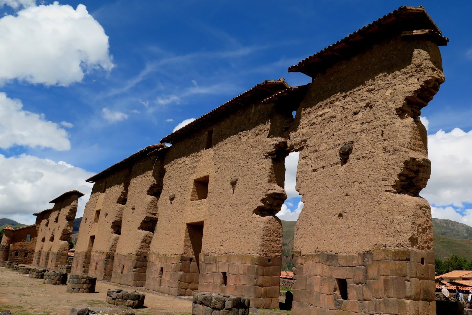
Racchi or Raqch'i

Raqch'i (Quechua) is an Inca archaeological site in Peru located in the Cusco Region, Canchis Province, San Pedro District, near the populated place Raqch'i. It is 3480 meters above sea level and 110 kilometers from the city of Cuzco

It also known as the Temple of Wiracocha, one of its constituents. Both lie along the Vilcanota River

Incan water reservoirs.


The hills in the background are terraced .
The Qucha (Quechua for "lake") is an artificial lake fed by a spring through two sets of finely constructed stone fountains with a raised platform beside one of them. It is a central feature of the site that is overlooked by both the temple and the raised platform, and is fed by the two fountains, which are of a type that the Inka used in cleansing rituals and as a place to make offerings

The fore ground also .

The Inka site at Raqch'i was a primary control point on a road system that originated in Cusco and expanded as the Inka empire grew. It is located in a valley known for sacred sites

Ancient water works .


The complex of Raqch'i consists of several different areas each designated with a specific function. Some have noted that these buildings may have been for religious and administrative officials

Others speculate that these buildings, paired with the scale of defenses may have been used as barracks to house troops.
There is some evidence that there was a village on the same site before the Inka conquest, but that it was the Inka who built the defensive changes to the city.

Raqch'i is located on a prominent ridge overlooking the surrounding valley which provides a natural defensive position. Just beyond the wall there is a large dry moat running along the edge of the ridge the site is situated on

Again the Incan stone works .

The most prominent structure is the Temple of Wiracocha, an enormous rectangular two-story roofed structure that measures 92 metres (302 ft) by 25.5 metres (84 ft). This structure consists of a central adobe wall some 18 to 20 meters in height with an andesite base

Prior to its destruction by the Spaniards, the temple had what is believed to be the largest single roof in the Incan Empire, having its peak at the central wall, then stretching over the columns and some 25 metres (82 ft) beyond on each side. The huge proportions of the temple, and its prominence on the site explain why the whole complex is also sometimes referred to as the Temple of Wiracocha.

It is flanked on each side by a row of eleven columns. The foundations measure 4 metres (13 ft) for both the wall and the columns are classic high Inca stonework with the remaining height built of adobe

According to Inca mythology, Wiracocha came to the region the Inka called Kacha but the local people there did not recognize him and tried to attack him. When he saw this, he made fire fall from the sky and burn the hills around the people. The Kacha went to Wiracocha pleading forgiveness and he put the fires out and explained to them who he was. They built a wak'a (shrine) where Wiracocha had stood and gave him many offerings. When the Inka Huayna Capac passed by the province of Kacha he saw the wak'a shrine of Viracocha in the midst of the plain and he asked why it was there. The people of the province told him of the miracle that Viracocha had performed. He decided that the remembrance of this event should be greater and ordered the erection of the temple

Adjoining the temple to the north are twelve living quarters which would have housed both priests and local administrators. The living area is divided into separate squared lots the largest of which is roughly 4x6m. All have niches in their walls which might have been used for storage, though some of the niches have cover posts, suggesting they may have held sacred objects

To the eastern side of the temple are 152 round qullqas in parallel lines, each measuring some 10 metres (33 ft) in diameter. These storehouses were used to hold grains, such as corn and quinoa, that would have been used for ceremonial purposes as well as pottery, woven cloth and military equipment.

The storehouses are also unique as unlike other structures throughout the empire they are not square cornered. The reason for this is unknown.

To the west of the temple is a large field, now used by locals for farming, that might have been a fairground or to hold overflow of worshipers from the temple itself. On the far western edge of this field is a set of baths similar to ceremonial baths at important sites throughout the empire.

The only remains now left .

A nice design .

The entrance has the usual tourist trap .

A really nice experience .

Now we go up .

Mountains and snow .

The Altiplano (Spanish for "high plain"), Collao (Quechua and Aymara: Qullaw, meaning "place of the Qulla"), Andean Plateauor Bolivian Plateau, in west-central South America, is the area where the Andes are the widest. It is the most extensive area of high plateau on Earth outside Tibet. The bulk of the Altiplano lies in Bolivia, but its northern parts lie in Peru, and its southern parts lie in Chile and Argentina.

The Altiplano was the site of several pre-Colombian cultures, including the Chiripa, Tiawanaku and the Inca Empire. Spain conquered the region in the 16th century.

This is summer. And its cold .

The highest part of our trip. 4335 m or 14,222 Feet .

And a tourist market .

So we stop and enjoy the views .

Really nice .

Huge peaks all around .

Memories .

Someone is absolutely thrilled .

Back to the main program .

Views . See those dots .

Llamas .

Soon its back on our way...

To our next stop .

Pukara, Puno
is a town in the Puno Region, Lampa Province, Pucará District, Peru. It is located to the north-west of Lake Titicaca.


The bull is a local totem AKA torito.

Iglesia de Santa Isabel de Pucará, Perú

Unfortunately it was closed .

Impressive though .

Nearby there is a museum ...

This apparently is the only statue of a person holding a decapitated head .

Gangster .

Small museum...

So its back on the bus .

We're headed to Puno .

Which is a city right on Lake Titicaca.

On the way we pass the regional capital .

Juliaca is the capital of San Roman Province in the Puno Region of southeastern Peru. It is the region's largest city with a population of 225,146 inhabitants (2007). On the Altiplano, Juliaca is 3,825 metres (12,549 ft) above sea level, is located on the Collao Plateau and is northwest of Lake Titicaca (45 km). It is the largest trade center in the Puno region.

Tuk -tuks .

Need a bit of progress here .

A country fair was ongoing.

Nice costumes .

The roads were closed so we had to take a detour .

Their actual attire .

After a few hours we finally see ....

Lake Titicaca .

The streets of Puno .

Unfinished. A common theme .

Day 8
Today its lake tour time .
We have a boat just for ourselves .

Looking back on Puno .

Single boat just for madam .

See.
We're going to see the man made floating islands of Lake Titicaca .

Some one is more interested in her bling .

The reeds are on the water .

In the distance we see the islands .

I decided to stand on the boat roof .

Toll gate .

The "Floating Islands" are small man-made islands constructed by the Uros (or Uru) people from layers of cut totora, a thick buoyant reed that grows abundantly in the shallows of Lake Titicaca. The Uros harvest the reeds that naturally grow on the lake's banks to make the islands by continuously adding reeds to the surface.

According to legend, the Uru people originated in the Amazon and migrated to the area of Lake Titicaca in the pre-Columbian era, where they were oppressed by the local population and were unable to secure land of their own. They built the reed islands, which could be moved into deep water or to different parts of the lake as necessary, for greater safety from their hostile neighbors on land.

Golden in color, many of the islands measure about 15 by 15 metres (50 by 50 ft), and the largest are approximately half the size of a football field. Each island contains several thatched houses, typically belonging to members of a single extended family. Some of the islands have watchtowers and other buildings, also constructed of reeds.

As of 2011, about 1,200 Uros lived on an archipelago of 60 artificial islands, clustering in the western corner of the lake near Puno, Titicaca's major Peruvian port town.

We're going there .

Spongy...

Almost everything is made from the reeds .

The Uru use bundles of dried totora reeds to make reed boats (balsas), and to make the islands themselves

The islets are made of totora reeds, which grow in the lake. The dense roots that the plants develop and interweave form a natural layer called Khili (about one to two meters thick) that support the islands. They are anchored with ropes attached to sticks driven into the bottom of the lake. The reeds at the bottoms of the islands rot away fairly quickly, so new reeds are added to the top constantly, about every three months; this is what makes it exciting for tourists when walking on the island

Where we are .

Each step on an island sinks about 2-4" depending on the density of the ground underfoot. As the reeds dry, they break up more and more as they are walked upon. As the reed breaks up and moisture gets to it, it rots, and a new layer has to be added to it. It is a lot of work to maintain the islands.

The Uru's islands are located at 3810 meters above sea level, and just five kilometers west from Puno port

Small but cozy .

Back on the boat .

We leave the floating islands .


And head out...

Towards open water .

High peaks in the distance .

The islands here are terraced by the ancient Incans .

Its a huge lake .

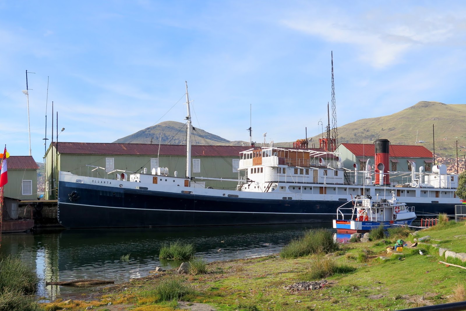
Lake Titicaca is a large, deep lake in the Andes on the border of Bolivia and Peru, often called the "highest navigable lake" in the world. By volume of water and by surface area, it is the largest lake in South America

Blue everywhere .

Lake Titicaca has a surface elevation of 3,812 metres (12,507 ft). The "highest navigable lake" claim is generally considered to refer to commercial craft. Numerous smaller bodies of water around the world are at higher elevations. For many years the largest vessel afloat on the lake was the 2,200-ton, 79-metre (259 ft) SS Ollanta. Today the largest vessel is most likely the similarly sized train barge/float Manco Capac, operated by PeruRail

Other cultures lived on Lake Titicaca prior to the arrival of the Incas. In 2000, a team of international archaeologists found the ruins of an underwater temple, thought to be between 1,000 and 1,500 years old, perhaps built by the Tiwanaku people. The ruins have been measured to be 200 by 50 m (660 by 160 ft)

That's Bolivia .

We reach our destination .

Now we walk...

...all uphill...

At elevation . Fun .

Taquile is a hilly island located 45 km (28 mi) east of Puno. It is narrow and long and was used as a prison during the Spanish Colony and into the 20th century. In 1970 it became property of the Taquile people, who have inhabited the island since then (current population around 2,200

The Taquiean Island is 5.5 by 1.6 km (3.42 by 0.99 mi) in size (maximum measurements), with an area of 5.72 km2 (2.21 sq mi). The highest point of the island is 4,050 m (13,290 ft) above sea level and the main village is at 3,950 m (12,960 ft)

Pre-Inca ruins are found on the highest part of the island, and agricultural terraces on hillsides.

From the hillsides of Taquile you have a view over the white snow tops of the Bolivian mountains.

The inhabitants, known as Taquileños, are southern Quechua speakers

Life on Taquile is still largely unchanged by mainland modernities. There are no cars on the island and no hotels and a few small stores sell basic goods. Most families use candles or flashlights powered by batteries or hand-cranks.

On clear nights, Taquile is a perfect place for star gazing and you furthermore experience much lightning in the horizon due to electric activity in the area.

At the top .

Taquileans are also known for having created an innovative, community-controlled tourism model, offering home stays, transportation, and restaurants to tourists

The people in Taquile run their society based on community collectivism and on the Inca moral code ama sua, ama llulla, ama qhilla, (do not steal, do not lie, do not be lazy

Amazing views .

The old church tower. .

And the main square .

A simple life .

A more modern church .

Taquileños are known for their fine handwoven textiles and clothing, which are regarded as among the highest-quality handicrafts in Peru. Knitting is exclusively performed by males, beginning in early boyhood. Women spin wool and use vegetables and minerals to dye the wool to be used by the community. Women are also the weavers of the Chumpis, the wide belts with woven designs worn by everyone in the community of Taquile

From here we will walk around the island .

And take in the views .

Amazing everywhere you look .

Memories .

One day when we are older....

...we will look back at these times with a smile .

The bunny adventures :-)

Local handicrafts .

Then the views .

Awesome .

The people work hard .

In their little paradise .

Ancient Incan terraces everywhere .

Like so .

Almost at the end .

The other side of the island .

Still amazing views .

We head down .

See the neighbouring islands...

Incan terraces.

The amount of labour .

Before we catch our boat.

We stop here .

For lunch .

With a view .

Then its back to Puno .

Its a long story but our local agent messed up our Bolivian visa. We managed to sort it out and tomorrow its Bolivia . 

No comments:
Post a Comment